Critical Fire Weather Risk Declared Across Four Corners Region as Dry Thunderstorms and Windy Conditions Raise Wildfire Danger
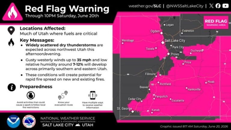
NORMAN, OK – The Storm Prediction Center has issued a Critical Fire Weather Risk for portions of the eastern Great Basin into the Four Corners region, warning that dry and windy conditions will create a heightened wildfire danger today, Saturday, June 20, 2026.
Critical Risk Centers on the Four Corners Region
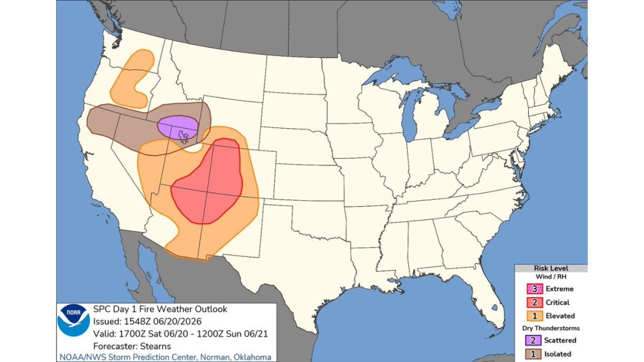
The outlook, issued at 10:49 AM CDT and valid from 1700Z Saturday, June 20 through 1200Z Sunday, June 21, places the most serious Critical Risk zone over a concentrated area stretching across parts of Arizona, Utah, Colorado, and New Mexico. Within a Critical Risk area, dry and windy conditions combine to create an environment where any spark, whether from lightning, equipment, or human activity, can rapidly grow into a fast spreading wildfire.
Scattered Dry Thunderstorms Threaten the Northeastern Great Basin
A separate area of concern sits over portions of the northeastern Great Basin, where scattered dry thunderstorms are expected. Dry thunderstorms produce lightning with little to no rainfall reaching the ground, making them one of the most dangerous triggers for new wildfire starts since the lightning can ignite dry vegetation without enough moisture to extinguish it.
Elevated Risk Surrounds the Core Threat Areas
A broader Elevated Risk zone wraps around both the Critical Risk area and the dry thunderstorm zone, extending from parts of the Pacific Northwest down through California and into the Southwest. While not as severe as the Critical or Extreme categories, an Elevated Risk still signals that fire weather conditions are favorable enough to warrant close attention from residents and fire crews across the region.
Why These Conditions Matter for Wildfire Spread
Fire weather outlooks like this one combine low relative humidity, gusty winds, and dry fuels to assess how quickly a fire could spread if one were to start. When all three factors align, as they are expected to today across the Four Corners region, existing fires can grow rapidly and new ignitions can become dangerous very quickly.
This outlook was issued by forecaster Stearns with the NOAA NWS Storm Prediction Center in Norman, Oklahoma, and conditions are expected to persist through the overnight hours into Sunday.
Fire weather conditions like these can turn a single spark into a major wildfire within hours. Stay with pinewhispers.net for updates as this critical fire weather event continues to unfold across the Southwest.