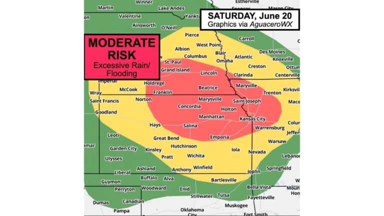
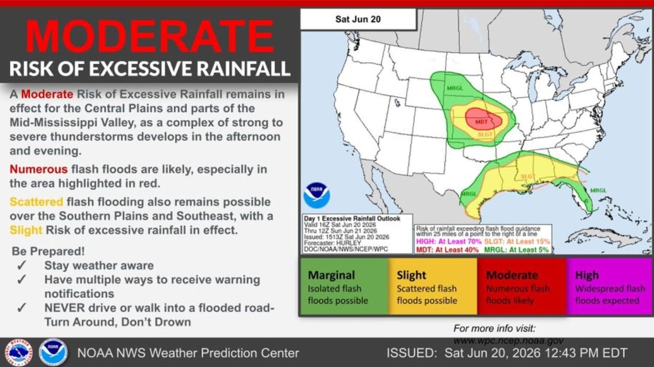
Moderate Risk of Excessive Rainfall Declared Across Central Plains and Mid-Mississippi Valley as Numerous Flash Floods Likely Saturday
WASHINGTON, DC – The NOAA Weather Prediction Center has issued a Moderate Risk of Excessive Rainfall for parts of the Central Plains and Mid-Mississippi Valley, warning that numerous flash floods are likely as a complex of strong to severe thunderstorms develops Saturday afternoon and evening.
Numerous Flash Floods Likely in the Red Highlighted Zone
According to the outlook, valid from 16Z Saturday, June 20 through 12Z Sunday, June 21, 2026, the Moderate Risk zone covers a concentrated area where numerous flash floods are likely, particularly in the region highlighted in red on the official map. A Moderate Risk indicates at least a 40 percent chance of rainfall exceeding flash flood guidance within 25 miles of any given point in that zone, making it one of the more serious flood risk levels the Weather Prediction Center issues.
Slight Risk Extends Into the Southern Plains and Southeast
A broader Slight Risk zone surrounds the Moderate Risk area, stretching across portions of the Southern Plains and Southeast, where scattered flash flooding is possible. A Slight Risk reflects at least a 15 percent chance of rainfall exceeding flash flood guidance in that area. An even wider Marginal Risk zone, indicating isolated flash flood potential with at least a 5 percent chance, extends further outward across parts of the central and southern United States.
What Triggers the Flooding Risk Saturday
The flooding threat is being driven by a developing complex of strong to severe thunderstorms expected to form during the afternoon and evening hours. As these storms cluster and move slowly across saturated or vulnerable terrain, heavy rainfall rates can quickly overwhelm drainage systems and low-lying areas, leading to fast developing flash floods with little warning time.
Safety Reminders as Storms Develop This Weekend
Forecasters are urging residents across the highlighted risk areas to stay weather aware throughout the day and to have multiple ways to receive emergency alerts in case warnings are issued. The most critical reminder from the Weather Prediction Center is to never drive or walk into a flooded roadway, following the well known guidance to turn around rather than risk being swept away.
This outlook was issued by forecaster Hurley with the NOAA NWS Weather Prediction Center at 12:43 PM EDT on Saturday, June 20, 2026, and conditions are expected to evolve quickly as the afternoon storms develop.
Flash flooding can turn a calm afternoon into a dangerous situation within minutes across the Central Plains today. Stay with pinewhispers.net for updates as this storm system continues to develop through the evening.