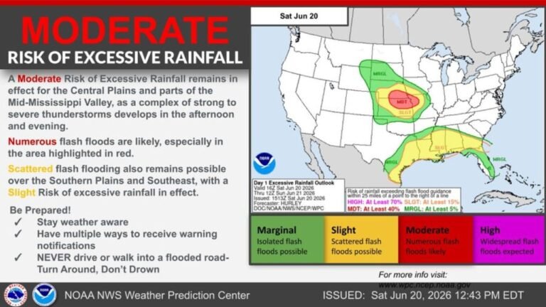
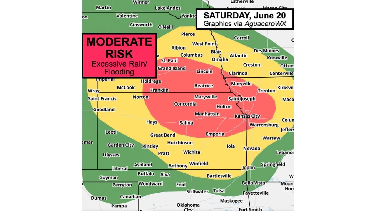
Kansas City Under Moderate Risk of Flash Flooding as Several Inches of Training Storms Threaten the Region Saturday Night
KANSAS CITY, MO – Concern is growing for possible flooding this evening as the Weather Prediction Center has placed Kansas City inside a Moderate Risk zone for flash flooding and excessive rainfall on Saturday, June 20, 2026, with several inches of rain expected to fall through the night.
Moderate Risk Zone Stretches From Nebraska to Kansas City
The Moderate Risk area, shown in red on the latest outlook, covers a wide stretch of the region including Lincoln, Beatrice, Marysville, Concordia, Manhattan, Salina, Holton, Saint Joseph, and Kansas City. A Moderate Risk is one of the more serious flood categories issued by forecasters, signaling a high likelihood of excessive rainfall and flash flooding capable of impacting roads, low lying neighborhoods, and waterways across the area.
Training Storms Set Up Repeated Waterlogged Downpours
The primary concern driving this risk is a weather pattern known as training, where storm after storm moves over the same areas in succession, similar to train cars following the same track. This repeated heavy rainfall over the same communities can quickly overwhelm soil and drainage systems that are not able to absorb water fast enough between downpours, leading to rapid and dangerous flash flooding even without a single massive storm.
Slight and Marginal Risk Zones Surround the Core Threat
Surrounding the Moderate Risk area, a broader Slight Risk zone extends across much of Nebraska, Kansas, and into parts of Missouri and Oklahoma, including areas near Omaha, Wichita, Hutchinson, and Joplin. An even wider Marginal Risk zone stretches further outward, covering additional communities across the central Plains where isolated flooding remains possible but less likely than in the core threat area.
Several Inches of Rain Expected Overnight in Kansas City
Forecasters are specifically warning that Kansas City could see several inches of rain tonight, raising concerns for fast rising water on roads and in flood prone areas as the overnight hours progress. Residents in and around the metro area should avoid driving through any flooded roadways and stay alert to changing conditions as storms move through.
This flooding setup has the potential to escalate quickly once storms begin training over the same communities tonight. Stay with pinewhispers.net for updates as conditions develop across Kansas City and the surrounding region through the overnight hours.